
Barcelona May 21st 2015.- AndSoft, European company expert in developing software full web for transport and Logistics companies, will present on its stand B.231 (SIL 2015, Facility Montjuic-Plaza de Spain, Barcelona fairgrounds) its innovation: “AndSoft Mapping Tool” which is a part of its technological platform e-TMS. This is a new solution developed with AndSoft’s partner PTV with the following novelties:
● Direct assignment of routes on a map simplifying this process.
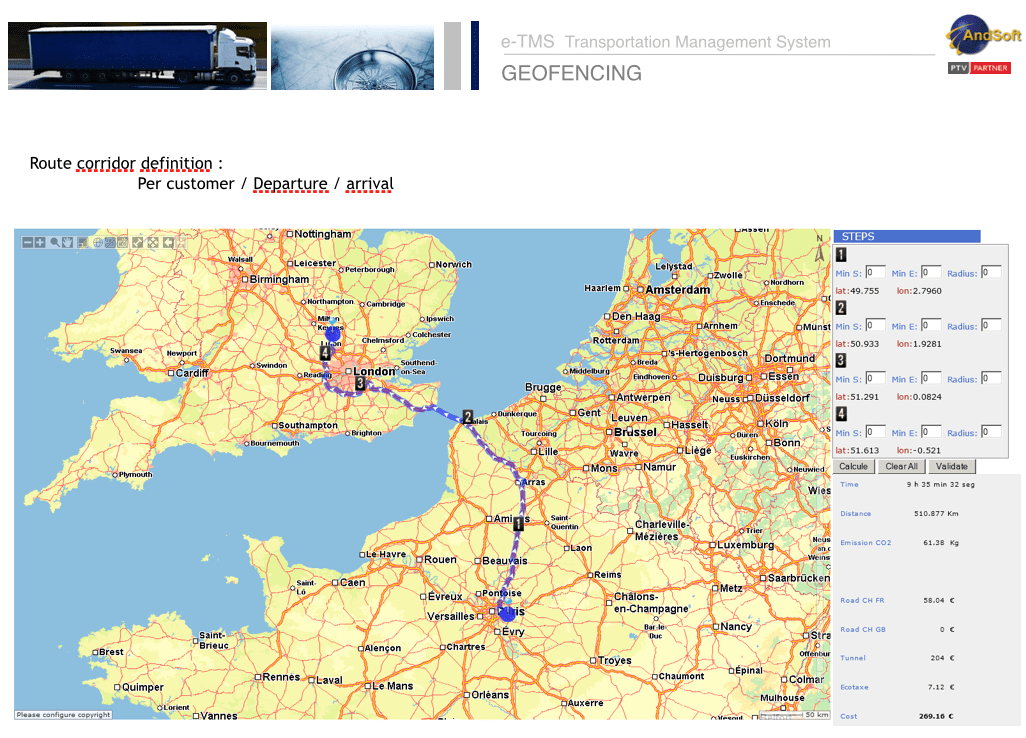
● Geofencing: Control in real time of the exact location of the truck and its transit on the marked route. If it moves away from parameterized distances in the system an alarm is automatically sent to the headquarters or to possible security companies that have been contracted.
● It calculates the arrival time for each route with the possibility of a warning in case of delays.
“AndSoft Mapping Tool” will be explained during the 17th edition of the SIL. It is an evolution of the RoadCost module and is composed of three new services:
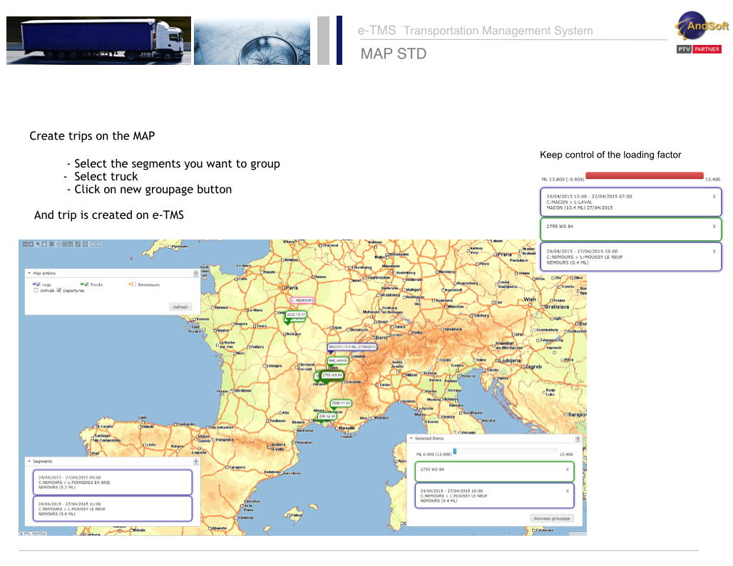
1-. Map Planning: It allows numerous functionalities for each trip. For example, you can assign a trip to the fleet of trucks from the map (Create trips on the map), for both full loads and groupage. Also you can mark for each driver the geographical points where he must cross on his route, reducing the errors of correct address for the final destination. In short, a new display interface of allocation of routes in which everything is done directly on the map.
2-. RoadCost: Statistics module to calculate the most optimal route between two points (the shortest, fastest and cheapest). It also calculates all the costs associated to the route and the impact of the carbon footprint.
3-. Mapping +: It is composed of the following modules. Geocode converts any address into Geopositions so AndSoft can trace a route on the map. Geofencing: Controls in real time that the truck is following exactly the determined route or zone. E.T.A control (Estimated Time of Arrival) to calculate “On Time” trips or possible delays.
These types of tools are more and more on demand by road transport companies, because they cover in graphic and easy way the core business of transport and logistics operators.
More information at:
AndSoft SIL Barcelona 2015
Stand: B.231
Contact: @victorvilasmatz
Thank you for your interest in AndSoft. Please reach us through the following contacts
EUROPE
19 rue de Bitbourg
L-1273 Luxembourg
Luxembourg
Phone : +352 24 52 1 – 413 email : info@andsoft.com
FRANCE
24, Bld Marcel Dassault
64200 Biarritz
Phone : +33 (0)5 59 43 87 06
Fax: +33 (0)5 59 43 87 01
email : info@andsoft.com
ANDORRA
Casa Ferre
Av. Del Traves, 2, 2º A
AD400 – La Massana – Andorra
Phone : +376 737 880
email : info@andsoft.com
SPAIN
Madrid
Zurbano,45-1ª
28010- Madrid – Espana
Phone : +(34) 911 853 129
Fax : +(34) 911 853 111
email : info@andsoft.com
Barcelone
World Trade Center – Muelle de Barcelona, Ed. Sur, 2ª Planta
08039 – Barcelona – Espana
Phone : +34 933 443 343
Fax : +34 933 443 299
email : info@andsoft.com

Reblogged this on VÍCTOR VILAS.
LikeLike